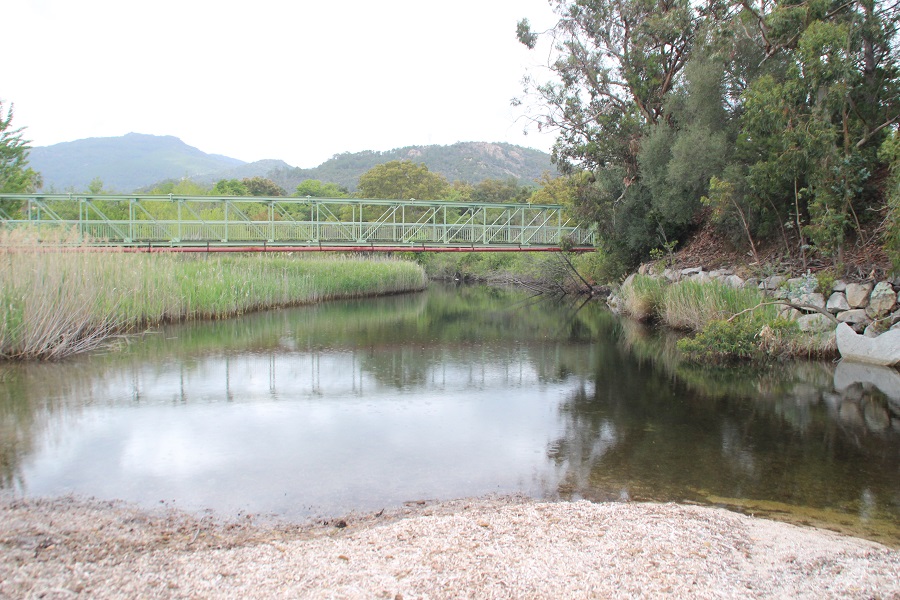
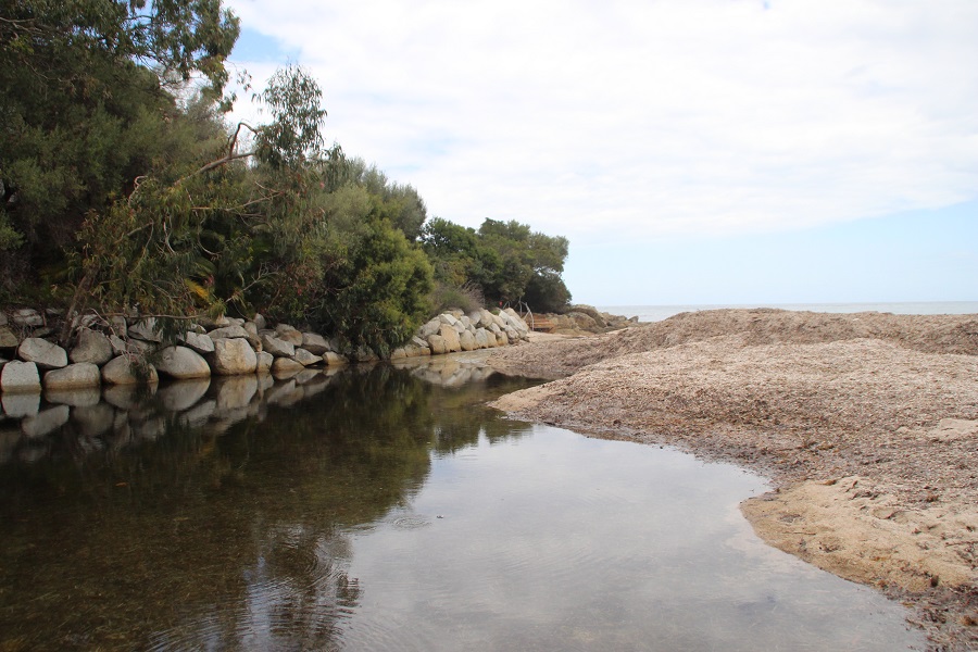
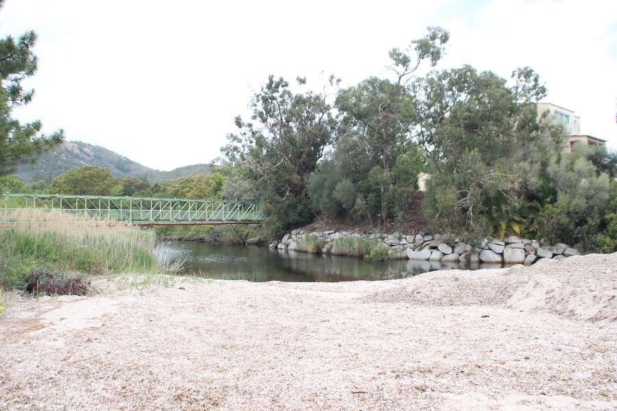
FR831COR107 - Estuaire du Favone
Wetland data
Basic information
| Wetland location: |
Marine / Coastal |
| Wetland type: |
Natural |
| Wetland area: |
1.4 Ha |
| Hydrological interaction: |
- |
| Water salinity: |
Brackish (0.5 - 18.0 g/l) |
| Type of fresh water input: |
Torrent / Stream - Unconfined aquifer |
| Surface water runoff |
Outflow from lakeshore or river |
| Open water area (%): |
76 - 95 |
| Hydroperiod: |
Permanent |
Geographic information
| Region: |
Corsica |
| Sub region: |
Sartène |
| Island: |
Corsica |
| Municipality: |
Sari-Solenzara |
| Longitude: |
9.394023 East |
| Latitude: |
41.776988 North |
Wetland condition
| Wetland status (MEDWET): |
3 - Original habitats / landform partially modified (10-50% untouched) |
Ramsar wetland type
| Type |
Coverage (%) |
| F -- Estuarine waters; permanent water of estuaries and estuarine systems of deltas |
> 95 |
Property status
Protection statuses
| Protection status category |
Protection status subcategory |
Area's name |
Code |
Coverage area (%) |
Legislation |
| Other |
ZNIEFF type I |
STATIONS BOTANIQUES DE L'ANSE DE FAVONE |
|
7 |
|
Ecosystem services
| Type of ecosystem service |
Ecosystem service |
Scale of Βenefit (%) |
Importance |
| Regulatory services |
Air quality regulation |
Local (<2km) |
1 - 1000 people benefitting |
| Regulatory services |
Local climate regulation |
Local (<2km) |
1 - 1000 people benefitting |
| Regulatory services |
Water regulation |
Local (<2km) |
1 - 1000 people benefitting |
| Regulatory services |
Water purification |
Local (<2km) |
1 - 1000 people benefitting |
| Regulatory services |
Visual buffering |
Local (<2km) |
1 - 1000 people benefitting |
| Regulatory services |
Noise buffering |
Local (<2km) |
1 - 1000 people benefitting |
| Supporting services |
Water recycling |
Local (<2km) |
1 - 1000 people benefitting |
Activities on wetland
| Activity |
Intensity |
| 220 = Leisure fishing |
Unknown |
| 230 = Hunting |
Unknown |
| 240 = Taking / Removal of fauna general |
Unknown |
| 502 = roads motorways |
High |
| 507 = bridge viaduct |
Medium |
| 622 = walking horseriding and non-motorised vehicles |
Medium |
| 690 = Other leisure and tourism impacts not referred to above |
Medium |
| 710 = Noise nuisance |
High |
| 870 = Dykes embankments artificial beaches general |
High |
| 871 = sea defense or coast protection works |
High |
| 900 = Erosion |
Unknown |
Activities on catchment area
| Activity |
Intensity |
| 210 = Professional fishing |
Low |
| 220 = Leisure fishing |
Medium |
| 230 = Hunting |
Medium |
| 402 = discontinuous urbanisation |
High |
| 501 = paths tracks cycling tracks |
Low |
| 502 = roads motorways |
High |
| 504 = port areas |
Low |
| 507 = bridge viaduct |
Medium |
| 530 = Improved access to site |
High |
| 621 = nautical sports |
Medium |
| 690 = Other leisure and tourism impacts not referred to above |
Medium |
| 710 = Noise nuisance |
Medium |
| 870 = Dykes embankments artificial beaches general |
High |
| 871 = sea defense or coast protection works |
High |
| 900 = Erosion |
Unknown |
Impacts
| Impact |
Intensity |
| EB- = Increase in aesthetic qualities |
Unknown |
| ED- = Increase in sediment removal/retention |
Unknown |
| ER- = Increase in flow regulation |
Unknown |
| ET- = Increase in toxicant removal/retention |
High |
Vegetation types
| Type |
Coverage (%) |
| Shrubby / Arborescent |
5 - 25 |
| Emergent |
51 - 75 |
Flora
| Species |
Presence status |
References |
| Alnus glutinosa (L.) Gaertn., 1790 |
Present |
|
| Anchusa crispa Viv., 1825 |
Present |
|
| Convolvulus soldanella L., 1753 |
Present |
|
| Crithmum maritimum L., 1753 |
Present |
|
| Eucalyptus globulus Labill., 1800 |
Present |
|
| Glaucium flavum Crantz, 1763 |
Present |
|
| Juncus sp. L., 1753 |
Present |
|
| Papaver rhoeas L., 1753 |
Present |
|
| Phragmites australis (Cav.) Trin. ex Steud., 1840 |
Present |
|
| Pinus pinaster Aiton, 1789 |
Present |
|
| Rubus fruticosus L., 1753 |
Present |
|
Fauna
Reptiles |
Presence status in wetland |
|
References |
| Emys orbicularis (Linnaeus, 1758) |
Present |
|
Fleuriau & Bosc (2013) - Etude de la ... |
Birds |
Number of individuals |
Nesting |
References |
| Corvus corone cornix (Linnaeus, 1758) |
|
|
|
| Corvus monedula (Linnaeus, 1758) |
|
|
|
| Hirundo rustica (Linnaeus, 1758) |
|
|
|