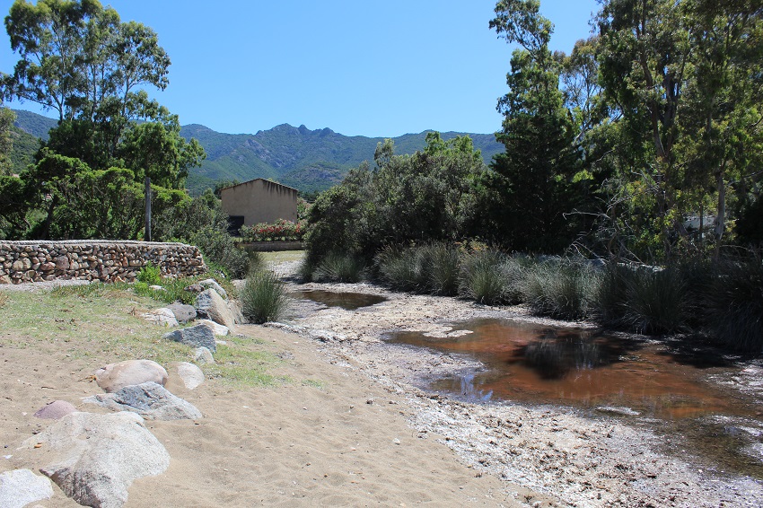
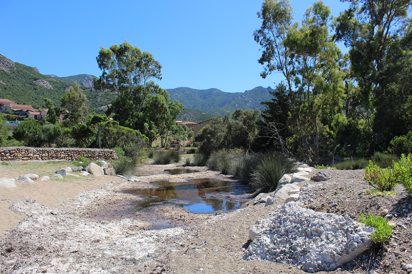
FR834COR339 - Estuaire du Tavulaghjiu
Wetland data
Basic information
| Wetland location: |
Marine / Coastal |
| Wetland type: |
Natural |
| Wetland area: |
1.4 Ha |
| Hydrological interaction: |
- |
| Water salinity: |
Brackish (0.5 - 18.0 g/l) |
| Type of fresh water input: |
Torrent / Stream - Unconfined aquifer |
| Surface water runoff |
Outflow from lakeshore or river |
| Open water area (%): |
5 - 25 |
| Hydroperiod: |
Permanent |
Geographic information
| Region: |
Corsica |
| Sub region: |
Calvi |
| Island: |
Corsica |
| Municipality: |
Galéria |
| Longitude: |
8.645305 East |
| Latitude: |
42.413302 North |
Wetland condition
| Wetland status (MEDWET): |
3 - Original habitats / landform partially modified (10-50% untouched) |
Ramsar wetland type
| Type |
Coverage (%) |
| F -- Estuarine waters; permanent water of estuaries and estuarine systems of deltas |
> 95 |
Property status
Protection statuses
| Protection status category |
Protection status subcategory |
Area's name |
Code |
Coverage area (%) |
Legislation |
| National/Regional Protection |
Regional natural Park |
Corse |
|
97 |
L.333-1 à L.333-4 Code Env. |
| International Protection |
Biosphere Reserve (buffer zone) |
Falasorma - Dui Sevi |
|
3 |
|
| International Protection |
Biosphere Reserve (transition zone) |
Falasorma - Dui Sevi |
|
97 |
|
| International Protection |
Special Protection Area (SPA) |
Gulf of Porto and Scandola peninsula |
FR9410023 |
3 |
D 95-631/05.05.95 |
| International Protection |
Special Area of Conservation (SAC) |
Porto/Scandola/Revellata/Calvi/Calanches de Piana (terrestrial and marine area) |
FR9400574 |
3 |
D 95-631/05.05.95 |
CDDA protection status
| CDDA code |
CDDA category |
| FR12 |
Site/Monument Registered |
| FR15 |
Regional Natural Park |
IUCN protection status
| IUCN code |
IUCN Category |
| III |
Monument ou élément naturel |
| IV |
Aire de gestion des habitats ou espèces |
| V |
Paysage terrestre ou marin protégé |
Ecosystem services
| Type of ecosystem service |
Ecosystem service |
Scale of Βenefit (%) |
Importance |
| Provisioning services |
Food |
Local (<2km) |
1 - 1000 people benefitting |
| Regulatory services |
Air quality regulation |
Local (<2km) |
1 - 1000 people benefitting |
| Regulatory services |
Local climate regulation |
Local (<2km) |
1 - 1000 people benefitting |
Activities on wetland
| Activity |
Intensity |
| 140 = Grazing |
Medium |
| 870 = Dykes embankments artificial beaches general |
High |
| 952 = eutrophication |
Medium |
| 954 = invasion by a species |
Medium |
Activities on catchment area
| Activity |
Intensity |
| 140 = Grazing |
Medium |
| 220 = Leisure fishing |
Low |
| 401 = continuous urbanisation |
Medium |
| 419 = other industrial / commercial areas |
Medium |
| 530 = Improved access to site |
High |
| 608 = camping and caravans |
Low |
| 621 = nautical sports |
Medium |
| 954 = invasion by a species |
Medium |
Impacts
| Impact |
Intensity |
| HL- = Habitat loss |
Medium |
| VCX = Introduction of exotic floral species |
High |
Vegetation types
| Type |
Coverage (%) |
| Shrubby / Arborescent |
26 - 50 |
| Emergent |
26 - 50 |
| Halophytic |
< 5 |
| Submerged |
< 5 |
Flora
| Species |
Presence status |
References |
| Carpobrotus sp. N.E.Br., 1925 |
Present |
|
| Crithmum maritimum L., 1753 |
Present |
|
| Dittrichia viscosa (L.) Greuter, 1973 |
Present |
|
| Eucalyptus globulus Labill., 1800 |
Present |
|
| Glaucium flavum Crantz, 1763 |
Present |
|
| Juncus acutus L., 1753 |
Present |
|
| Tamarix africana Poir., 1789 |
Present |
|
Fauna
Birds |
Number of individuals |
Nesting |
References |
| Carduelis carduelis (Linnaeus, 1758) |
|
|
|
| Corvus corone cornix (Linnaeus, 1758) |
|
|
|
| Passer domesticus (Linnaeus, 1758) |
|
|
|
| Ptyonoprogne rupestris (Scopoli, 1769) |
|
|
|
| Turdus merula (Linnaeus, 1758) |
|
|
|