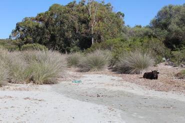
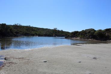
FR834COR364 - Estuaire de Cala di Malfacu
Wetland data
Basic information
| Wetland location: |
Marine / Coastal |
| Wetland type: |
Natural |
| Wetland area: |
1.9 Ha |
| Hydrological interaction: |
- |
| Water salinity: |
Brackish (0.5 - 18.0 g/l) |
| Type of fresh water input: |
Torrent / Stream - Unconfined aquifer |
| Surface water runoff |
Outflow from lakeshore or river |
| Open water area (%): |
5 - 25 |
| Hydroperiod: |
Seasonal |
Geographic information
| Region: |
Corsica |
| Sub region: |
Calvi |
| Island: |
Corsica |
| Municipality: |
Santo-Pietro-di-Tenda |
| Longitude: |
9.121685 East |
| Latitude: |
42.723996 North |
Wetland condition
| Wetland status (MEDWET): |
1 - Untouched. No signs of man-made changes |
Ramsar wetland type
| Type |
Coverage (%) |
| F -- Estuarine waters; permanent water of estuaries and estuarine systems of deltas |
> 95 |
Property status
| Conservatoire du littoral |
Protection statuses
| Protection status category |
Protection status subcategory |
Area's name |
Code |
Coverage area (%) |
Legislation |
| National/Regional Protection |
Marine natural Park |
Cap Corse et Agriate |
|
3 |
L.334-3 à L.334-8 Code Env. |
| National/Regional Protection |
Land acquired by the Conservatoire du littoral |
AGRIATE |
|
82 |
L.322-1 Code Env. |
| Other |
ZNIEFF type II |
DESERT DES AGRIATE |
|
70 |
|
| International Protection |
Special Area of Conservation (SAC) |
Agriates |
FR9400570 |
100 |
D 95-631/05.05.95 |
CDDA protection status
| CDDA code |
CDDA category |
| FR12 |
Site/Monument Registered |
| FR14 |
Site acquired by the Conservatoire du littoral |
IUCN protection status
| IUCN code |
IUCN Category |
| III |
Monument ou élément naturel |
| IV |
Aire de gestion des habitats ou espèces |
| V |
Paysage terrestre ou marin protégé |
| VI |
Aire protégée avec utilisation durable des ressources naturelles |
Ecosystem services
| Type of ecosystem service |
Ecosystem service |
Scale of Βenefit (%) |
Importance |
| Provisioning services |
Food |
Local (<2km) |
1 - 1000 people benefitting |
| Supporting services |
Provision of habitat |
Local (<2km) |
1 - 1000 people benefitting |
Activities on wetland
| Activity |
Intensity |
| 010 = Habitat conservation |
Medium |
| 020 = Resource conservation |
Medium |
| 030 = Species conservation |
Medium |
| 040 = Land restoration |
Medium |
| 140 = Grazing |
Medium |
| 421 = disposal of household waste |
Medium |
| 501 = paths tracks cycling tracks |
Low |
| 530 = Improved access to site |
Low |
Activities on catchment area
| Activity |
Intensity |
| 010 = Habitat conservation |
High |
| 020 = Resource conservation |
High |
| 030 = Species conservation |
High |
| 040 = Land restoration |
High |
| 140 = Grazing |
Medium |
| 501 = paths tracks cycling tracks |
Medium |
| 530 = Improved access to site |
Low |
| 621 = nautical sports |
High |
| 954 = invasion by a species |
Medium |
Impacts
| Impact |
Intensity |
| EW- = Increase in wilderness/wildlife values |
Medium |
Habitat types
| Type |
Coverage (%) |
| 1140 Mudflats and sandflats not covered by seawater at low tide |
< 5 |
| 2250 * Coastal dunes with Juniperus spp |
51 - 75 |
| 6420 Mediterranean tall humid grasslands of the Molinio-Holoschoenion |
5 - 25 |
| 9320 Olea and Ceratonia forests |
< 5 |
Vegetation types
| Type |
Coverage (%) |
| Shrubby / Arborescent |
< 5 |
| Emergent |
76 - 95 |
Flora
| Species |
Presence status |
References |
| Convolvulus soldanella L., 1753 |
Present |
|
| Eucalyptus globulus Labill., 1800 |
Present |
|
| Juncus acutus L., 1753 |
Present |
|
| Juncus conglomeratus L., 1753 |
Present |
|


